
At a glance
Primary Partner: Earth Economics
Status: Completed, 2014
Models: Flood regulation, carbon sequestration and storage, sediment regulation, aesthetic viewsheds, open space proximity
Highlights: Analysis of ecosystem service provision, use, and flows and their changes under alternative urban growth scenarios
Overview
This case study enabled the analysis of three aspects of ecosystem services mapping and modeling. First, we mapped the difference between theoretical or in situ provision of services, i.e., ecosystems’ capacity to supply services, and their actual provision when accounting for the location of beneficiaries and the flows connecting people and ecosystems. With the exception of carbon sequestration, regions that actually provided services to people, i.e., connected to beneficiaries via flow paths, amounted to 16-66% of those theoretically capable of supplying services, i.e., all ecosystems across the landscape. These results offer a more complete understanding of the spatial dynamics of ecosystem services and their effects, and may provide a sounder basis for economic valuation and policy applications than studies that consider only theoretical service provision and/or use (Bagstad et al. 2014).
Second, in a comparison with three European case studies, we estimated the difference in ecosystem service values obtained when using coarser resolution global datasets (300 m to 1 km resolution) versus high-resolution local datasets (30 m). We found greater differences for some services than others, depending on how clustered the service provision is as well as underlying terrain characteristics. The impact of data choices on modeling results will be particularly important in the developing world, where high-resolution datasets are not available (Grȇt-Regamey et al. 2014).
Third, we compared how natural capital stocks decline while ecosystem service flows increase under different urban growth scenarios. This occurs as land conversion reduces ecosystems’ capacity to supply services while urban growth adds new beneficiaries to the landscape, particularly at the urban fringe. Past studies’ assertions that urbanization decreases flows of ecosystem services are thus too simplistic, and urban planning should carefully consider both impacts to ecosystem services that accompany land conversion and the location and number of beneficiaries of ecosystem services can affect their flow and value (Zank et al. 2016).
References

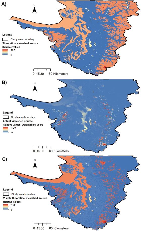
Scenic viewshed quality before (top) and after (bottom) accounting for the location of beneficiaries